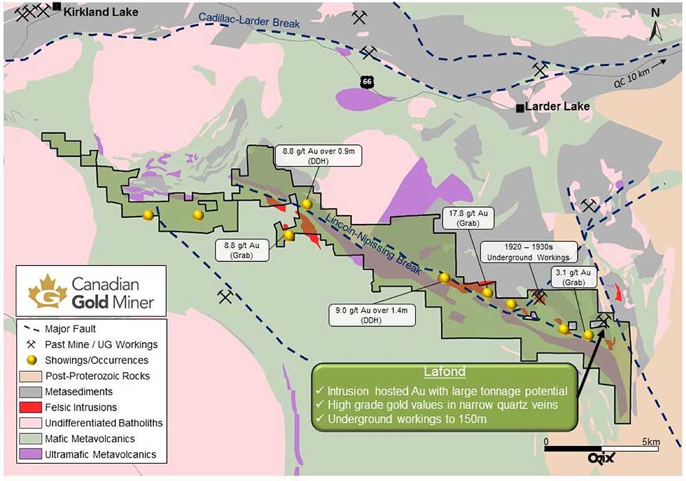
Sudbury, July 27, 2017 – Canadian Gold Miner Corp (“CGM”, the Company) and Transition Metals Corp. (XTM – TSX.V, “Transition”) are pleased to announce preliminary sampling results from CGM’s South Kirkland project. The Lafond showing is one of 7 gold mineralized zones that the Company has identified in the southeastern portion of the South Kirkland project located 10 kilometres southeast of Larder Lake Ontario. Figure 1 depicts the location of the Lafond showing within an outline of CGM’s south Kirkland project area.
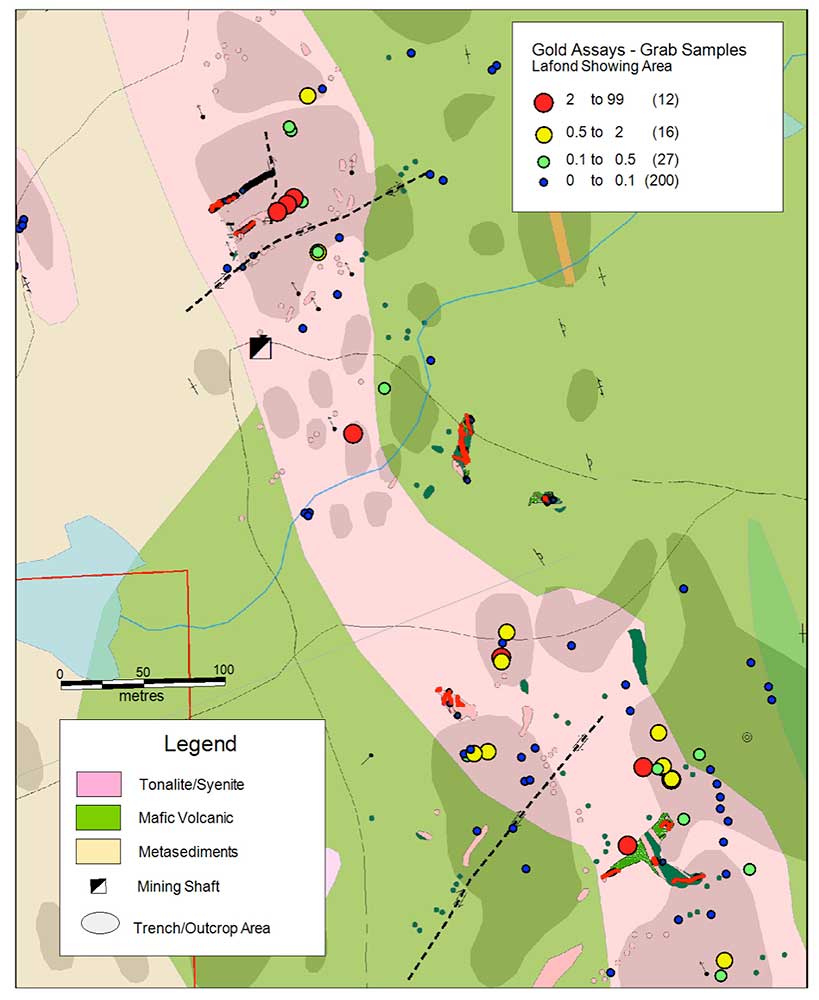
Initial assay results from 62 grab samples collected from bedrock exposures in the vicinity of the Lafond showing have returned gold values ranging from <0.01 to 29.5 grams per tonne gold (g/t Au) with a mean value of 2.2 g/t Au (see Table 1). Figure 2 presents a detailed map of the Lafond area that illustrates sample locations and values. Please note that grab samples are selective samples are not necessarily representative of the mineralization hosted on the property.
Commenting on the results, CGM CEO Greg Collins, P.Geo said, “We are very encouraged by what we are seeing at Lafond so far. The results indicate an approximately 700 by 100 metre wide gold mineralized exposure around the known high grade vein occurrences located in the vicinity of the Lafond shaft. This highlights the potential for a larger and more widespread system of gold mineralization on the property. Work is progressing to expose more bedrock in preparation for channel sampling and diamond drilling.”
About the Lafond Showing:
The Lafond showing is one of 7 occurrences within the South Kirkland project area selected for surface mapping and sampling work this summer. At Lafond, a pre-1928 shaft was sunk to a depth of 160 metres with approximately 460 metres of lateral development completed on 3 levels to test a series of high-grade quartz veins hosted in a large (approximately 100 m wide by a minimum 800 m long as exposed) alkaline to calc-alkaline intrusive complex. Historically, more than 13 major veins have been identified on the property with the No, 9, 10, and 11 veins located north of the shaft being the main focus of historic exploration. On surface, the No. 9 vein is 0.5 to 2 metres wide, the No.10 Vein up to 0.5 metres wide and the No. 11 Vein averages 2 metres wide at the west end and 0.5 metres near the east end. Historical assay records from ten drill holes at Lafond reported intersecting values including 9.05 g/t Au over 1.68 metres, 7.54 g/t over 0.30 metres, and 2.07 g/t Au over 3.75 metres¹. Cited grades have been sourced from historical assessment reports that the Company have not been independently authenticated by the Qualified Person and as such should not be relied upon as being accurate by the reader.
¹Source: MNDM 1984 Assessment Report 32D04SE0351
South Kirkland Exploration Plans
Plans for the summer include mechanical trenching, detailed mapping, and channel sampling at the south Kirkland project. The Company is completing the work ahead of a planned 1,500 to 3,500 metre diamond drilling program expected to commence following completion and review of data from the trenching work now in progress.
Table 1. Lafond Surface Mapping Samples
| Sample | Type | Easting (metres) | Northing (metres) | Au (g/t) |
| L783538 | Trench | 600420 | 5317030 | 29.50 |
| L784259 | Trench | 600184 | 5317433 | 18.80 |
| L784260 | Trench | 600184 | 5317433 | 17.80 |
| L783540 | Trench | 600403 | 5317039 | 14.50 |
| L784261 | Trench | 600178 | 5317428 | 9.82 |
| L783539 | Trench | 600420 | 5317030 | 9.51 |
| L784258 | Trench | 600188 | 5317437 | 7.33 |
| L784160 | Outcrop | 600394 | 5316985 | 5.76 |
| L784278 | Outcrop | 600225 | 5317274 | 5.12 |
| L783541 | Trench | 600413 | 5317038 | 3.29 |
| L784296 | Outcrop | 600316 | 5317117 | 2.82 |
| L784273 | Outcrop | 600196 | 5317507 | 1.60 |
| L784253 | Outcrop | 600203 | 5317399 | 1.56 |
| L784159 | Outcrop | 600394 | 5316985 | 1.39 |
| L784174 | Outcrop | 600453 | 5316904 | 1.38 |
| L784293 | Outcrop | 600319 | 5317134 | 0.67 |
| L784297 | Outcrop | 600316 | 5317114 | 0.65 |
| L784153 | Outcrop | 600300 | 5317051 | 0.61 |
| L784257 | Trench | 600193 | 5317434 | 0.43 |
| L784276 | Outcrop | 600185 | 5317486 | 0.37 |
| L783537 | Trench | 600395 | 5317077 | 0.35 |
| L784274 | Outcrop | 600186 | 5317483 | 0.35 |
| L784254 | Outcrop | 600203 | 5317399 | 0.34 |
| L784171 | Outcrop | 600468 | 5316966 | 0.21 |
| L784277 | Outcrop | 600244 | 5317304 | 0.12 |
| L784161 | Outcrop | 600428 | 5317002 | 0.12 |
| L784151 | Outcrop | 600296 | 5317049 | 0.12 |
| L784173 | Outcrop | 600451 | 5316893 | 0.12 |
| L784178 | Outcrop | 600450 | 5317016 | 0.09 |
| L784154 | Outcrop | 600298 | 5317053 | 0.07 |
| L784169 | Outcrop | 600455 | 5316999 | 0.06 |
| L784281 | Outcrop | 600196 | 5317219 | 0.04 |
| L784252 | Outcrop | 600215 | 5317369 | 0.04 |
| L784162 | Outcrop | 600302 | 5316997 | 0.03 |
| L784167 | Outcrop | 600337 | 5317053 | 0.03 |
| L784256 | Outcrop | 600216 | 5317408 | 0.03 |
| L784272 | Outcrop | 600205 | 5317511 | 0.02 |
| L784168 | Outcrop | 600450 | 5317008 | 0.02 |
| L784179 | Outcrop | 600448 | 5317025 | 0.02 |
| L784165 | Outcrop | 600454 | 5316963 | 0.02 |
| L784157 | Outcrop | 600334 | 5317031 | 0.01 |
| L784251 | Outcrop | 600194 | 5317346 | 0.01 |
| L784282 | Outcrop | 600198 | 5317217 | 0.01 |
| L784292 | Outcrop | 600359 | 5317123 | 0.01 |
| L784158 | Outcrop | 600329 | 5317047 | <0.01 |
| L784166 | Outcrop | 600425 | 5316932 | <0.01 |
| L784177 | Outcrop | 600450 | 5317016 | <0.01 |
| L784299 | Outcrop | 600297 | 5317050 | <0.01 |
| L784152 | Outcrop | 600294 | 5317050 | <0.01 |
| L784176 | Outcrop | 600445 | 5316935 | <0.01 |
| L784279 | Outcrop | 600199 | 5317219 | <0.01 |
| L784284 | Outcrop | 600148 | 5317389 | <0.01 |
| L784285 | Outcrop | 600148 | 5317389 | <0.01 |
| L784294 | Outcrop | 600317 | 5317126 | <0.01 |
| L784295 | Outcrop | 600319 | 5317115 | <0.01 |
| L784156 | Outcrop | 600331 | 5317030 | <0.01 |
| L784163 | Outcrop | 600324 | 5316998 | <0.01 |
| L784164 | Outcrop | 600332 | 5316970 | <0.01 |
| L784170 | Outcrop | 600452 | 5316985 | <0.01 |
| L784172 | Outcrop | 600384 | 5316897 | <0.01 |
| L784187 | Outcrop | 600392 | 5317095 | <0.01 |
About Canadian Gold Miner Corp
Canadian Gold Miner Corp. is a Canadian private corporation focused on exploring for gold in the Larder Lake Mining District near Kirkland Lake. The Company was founded by Transition to leverage its data, expertise and extensive portfolio of high quality gold projects within the district. CGM has assembled a dominant land position in excess of 165 square kilometres around the Cadillac Larder, Lincoln-Nipissing and Ridout Structures in the southwestern part of the prolific Abitibi Greenstone belt in Ontario. The Abitibi Greenstone belt is Canada’s most prolific gold district with excellent mining infrastructure in place.
About Transition Metals Corp
Transition Metals Corp. (XTM -TSX.V) is a Canadian-based, multi-commodity project generator that specializes in converting new exploration ideas into Canadian discoveries. The award-winning team of geoscientists has extensive exploration experience in established, emerging and historic mining camps, and actively develops and tests new ideas for discovering mineralization in places that others have not looked, which often allows the company to acquire properties inexpensively. The company has an expanding portfolio that currently includes gold, copper, nickel and platinum projects primarily in Ontario, Nunavut, Northwest Territories, British Columbia, Saskatchewan and Minnesota that it seeks to advance through funding partnerships and subsidiary companies to maximize shareholder value. Transition Metals presently own approximately 50% of Canadian Gold Miner.
Qualified Person
The technical elements of this press release have been approved by Mr. Thomas Hart, P.Geo., V.P. Exploration for Canadian Gold Miner and a Qualified Person under National Instrument 43-101. All core samples were collected by Company representatives under the supervision of the Qualified Person and transported directly by the company to the lab. Transition Metals employs in-house QA/QC procedures that conform to industry best practices. All analytical work performed on core samples was conducted at ALS-Chemex with sample preparation completed in Sudbury, Ontario and analyses completed in North Vancouver, B.C. The quality system used by ALS-Chemex complies with international standards ISO 9001:2000 and ISO 17025:2005.
Cautionary Note on Forward-Looking Information
Except for statements of historical fact contained herein, the information in this news release constitutes "forward-looking information" within the meaning of Canadian securities law. Such forward-looking information may be identified by words such as "plans", "proposes", "estimates", "intends", "expects", "believes", "may", "will" and include without limitation, statements regarding estimated capital and operating costs, expected production timeline, benefits of updated development plans, foreign exchange assumptions and regulatory approvals. There can be no assurance that such statements will prove to be accurate; actual results and future events could differ materially from such statements. Factors that could cause actual results to differ materially include, among others, metal prices, competition, risks inherent in the mining industry, and regulatory risks. Most of these factors are outside the control of the Company. Investors are cautioned not to put undue reliance on forward-looking information. Except as otherwise required by applicable securities statutes or regulation, the Company expressly disclaims any intent or obligation to update publicly forward-looking information, whether as a result of new information, future events or otherwise.
Neither the TSX Venture Exchange nor its Regulation Services Provider (as that term is defined in the policies of the TSX Venture Exchange) accepts responsibility for the adequacy or accuracy of this release.
For more information about Canadian Gold Miner visit the company’s newly launched website at: www.canadiangoldminer.com or by contacting:
Greg Collins, P.Geo.
President and CEO
Canadian Gold Miner Corp.
Tel: (705) 872-6390
Scott McLean, P.Geo.
President and CEO
Transition Metals Corp
Tel: (705) 669-5090
Figure 1. Location of the Lafond occurrence and the South Kirkland Project Area, Near Kirkland Lake Ontario

Figure 2. Lafond Shaft area showing Sample Locations and Values

